What’s going on here?
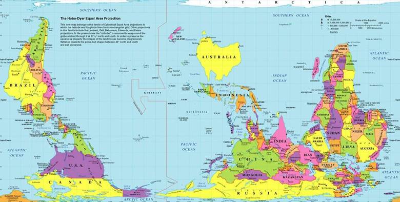
This map is the Hobo-Dyer Equal Area Projection map. It shows the globe from a different perspective than what we’re used to seeing, especially in our northern-hemisphere-centric view.
North and south are arbitrary, man-made designations. We’ve decided that north is up, but that’s not how our planet actually operates. Satellite videos of our globe show the reality. Without the usual map guideposts and orientation, you might not even recognize the countries you’re looking at.
The Hobo-Dyer map flips the hemispheres. Similarly the land mass shown on this map more accurately reflects actual area, with shapes towards the poles becoming flattened where our globe is smaller.
It’s the exact same world. It’s the exact same information we’ve always had. But by changing the perspective, we literally have a new worldview.

ha Ha! very clever…. I plan on sharing this with my Grade 7 Geography classes! a great discussion starter! thanks for posting
LikeLike
Glad it inspired you, Carla. It’s more than cleverness… it’s an invitation to rethink what we “know.” This map is technically more accurate than what we’ve been shown in our North American schools and puts a new perspective on our relative size and importance in the world. Google alternate maps – there are several common ones that redraw the globe with greater accuracy (e.g. for starters Greenland is NOT as big as Africa).
LikeLike